Intelligent business solutions where location matters
Whether you are looking at the best delivery routes, managing the assets spatially or confront with a strategic location problem – GIS is the go-to technology for Enterprises, Governments and consumers

MORE

Intelligent business solutions where location matters

Whether you are looking at the best delivery routes, managing the assets spatially or confront with a strategic location problem – GIS is the go-to technology for Enterprises, Governments and consumers. Our proven track record on services and solutions make smart mapping applications possible, turning location data into a key driver for your business growth.

We closely work with leading Engineering & Utility companies, Federal & Government departments, County & Local Administrations, Transportation and Urban Planning bodies across the globe to create a wide range of geo-spatial data and applications that provide intelligent insights that decision makers need for strategic leverage of their business.

Moving beyond conventional GIS

  • IoT – real-time visualization of live & stream data from connected sensors and devices from the Internet of Things ecosystem
  • Informational Edge through advanced Geo-Analytics – capabilities for Big data and geo- analytics to process massive data to perform deep and meaningful analysis to get spatio-temporal insights into your business data
  • Enterprise Integration – Integrate your existing GIS infrastructure with other enterprise business applications
  • Mobility – application solutions for seamless multi-platform and multi-device support for data collection and visualization for logistics, mining and utilities
  • Pixels to Insights - Digital Image Processing & Machine Learning workflows for object recognition, land cover mapping, change detection, dynamic forecasting, storm water modeling etc.
  • AR and VR enabled – Applications which blend 3D, Augmented Reality and Virtual Reality to provide enhanced view of your spatial data.
alternative

About NeST GIS

16+
Years
Across the world
300+
GIS
Professionals
50+
Application
Developers
2+
Million hours
of experience
alternative

NeST GIS is a products and services entity under NeST Information Technologies, offering advanced geospatial solutions with a focus on government, cadastral, utilities, transportation and facilities management. One of the NeST’s key differentiators in the industry is that it is a software development company that has added GIS as a horizontal technology focus area, rather than a ‘mapping’ company attempting software development in GIS. We help to GIS‐enable the business processes of our clients. NeST GIS has a strong focus in offering services built upon Esri technology. Besides providing data development and application development services, we have specialized in technology migration and GIS consulting services.

NeST GIS is ISO 27001, ISO 9001:2000, ISO 9001:2015, ISO 27001:2005 and CMMI Level 5 certified with mature production processes ensuring timely, cost‐effective, and quality deliverables. The division also successfully completed the Capability Maturity Model Integration with CMMI DEV v2.0 Maturity Level 5 certificate.

NeST GIS has been working with top global agencies over the past 16 plus years, which include government and federal departments, large utility companies and airliners across USA, Mexico, France, ME (Qatar, UAE, Oman, KSA, Kuwait and Lebanon), Asia Pacific (Singapore, Japan and Australia) and Nigeria

Our Team Of Leadership

"Good leaders are able to create an environment that will encourage all the members of their team to develop their skills and imagination"

alternative

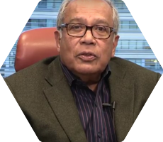
Javad K Hassan

Chairman

From an Engineer in semiconductor development and manufacturing to the post of head semiconductor development operations in just 10 years’ time at IBM, heading over 2000 engineers and scientists – Mr. Javad Hassan’s excellence had paved for a spectacular growth in his career which started in early 1968. During this period, he obtained over 20 patents for his inventions in semiconductor technology. In later years, he held the positions of the corporate Head of Engineering and Technology at IBM’s world headquarters in New York as well as the Head of their storage business. In 1988, he joined AMP Inc, world’s largest electronic components/connector company (a fortune 100 company), as their Corporate Head of Technology. In his next 10 years’ time, he diversified AMP into fibre-optics and wireless technologies. He retired from AMP as the President of Global Inter Connect Systems business in 1998 and started off his career as the entrepreneur in his own right. As Chairman, he has been the visionary guiding and managing the explosive growth of the Nest Group since its inception.

alternative

N Jehangir

Vice Chairman & MD

Mr. N. Jehangir, Vice-Chairman and the Group Managing Director, is an aggressive entrepreneur who has set up 30 diversified enterprises catering to the global market in the last 29 years. He brings to NeST, his rich experience in successfully setting up and managing state of the art Hitech industries in Kerala. He has won many laurels for his entrepreneurial achievements, such as – Best Regional Exporter Award, Best Entrepreneurship Award, Prime Minister’s Award for Technology Upgradation and Udyog Ratna Award from the Government of India for contribution in the field of Industrial development of the country, Top Exporter Award from Technopark, Thiruvananthapuram (Trivandrum), etc. He works closely with the government of Kerala, KSIDC etc for the development of industries in Kerala and promoting Kerala abroad as an investment destination.

alternative

Nazneen Jehangir

Executive Director & CEO

Ms. Nazneen Jehangir, joined NeST Group as its Executive Director and CEO (Software Business) in 2009. A trained Engineer, she has aggressively led the growth of NeST’s software businesses in the past 10 years, taking the company into new geographies, domains and technology areas, especially digital technologies, her core focus area. She also looks after the Group’s CSR and Education & Training initiatives and plays a leading role in local industrial conclaves such as CII, NASSCOM, etc. Destination Kerala, a leading business magazine, in partnership with Women Entrepreneurs Network (WEN) Kerala Chapter, All Ladies League (ALL) Kerala Chapter and TiE Kerala, had conferred her with the prestigious “Young Entrepreneur of the Year Award” in 2018.

Quality Journey

NeST is renowned for its versatility of standards and stringent in obtaining quality products and services through generic and domain specific certifications. NeST's corporate culture is based upon rigorous quality assurance measures to support our client processes. Our Quality Assurance Program assures that our services are not only of high quality, but also satisfy or exceed contractual requirements.

The Quality journey of NeST started right from the inception days and it is continuing with the aim of continual improvement by adapting the best practices followed in the software industry. NeST Information Technologies Pvt Ltd works in line with the requirements of the International standards such as ISO 9001:2015, ISO 27001:2013 and CMMI-Dev v2.0 (Maturity Level 5). These international standards promote the adoption of a process approach when developing, implementing and improving the effectiveness of a quality management system, to enhance customer satisfaction by meeting customer requirements .

The project management process is well defined in NeST Quality Management System with the principles of project planning, project monitoring and control, risk & opportunity management, configuration management and metric analysis.

We consider our customer as an important participant in our quality program. At the completion of every projects, we encourage our clients to complete an evaluation form that provides priceless feedback to NeST on the strengths and weaknesses of our system.

alternative

NeSTIT Quality Policy

“We are committed to comply with customer requirements, statutory and regulatory requirements and the requirements of all other interested parties by establishing and maintaining an appropriate quality management system. The quality management system shall be reviewed periodically to ensure that its effectiveness is maintained and is continually improved to exceed the expectations of all interested parties”.

Our Clients

Michael Baker
Maptech
Qatar Petroleum
Khatib & Alami
Sirs
SWWC
Center Point
CGIS Qatar
NYC
Newmark
Ministry of Transport & Communication
DRDO NPOL
Indigo
KSINC
KAHRA MAA
Data Trace
Executiive Snow Control
MMUP
Scout
Statistics Authority
ONIC
ISO
CWS
ICT Qatar

Services from NeST GIS

Our interdisciplinary team focuses on offering geospatial services for customers across multiple business and technical domains,
from spatial data services to location based application development and consulting services.

application

Application Services

With a wide range of services and skills, NeST has extensive experience of delivering...

alternative

Data Services

Use this service pack to give your company the necessary impulse to become an industry leader

alternative

Lidar Services

You already are a reference point in your industry now you need to learn about acquisitions

alternative

GIS Consultancy

You already are a reference point in your industry now you need to learn about acquisitions

alternative

Resource Augmentation

You already are a reference point in your industry now you need to learn about acquisitions

Application Services

With a wide range of services and skills, NeST has extensive experience of delivering end-to-end solutions for different IT needs from ideas to system analysis, design, implementation, testing, deployment, maintenance and support. Our solutions are based on industry standard Agile and Waterfall models.

The GIS Application Development team has skill sets ranging from Net, JavaScript (React, Angular), Java, Python. They have been part of implementing many custom tools within the GIS environment using these domains.

Enterprise Architecting

  • State-of-the-art GIS based on comprehensive enterprise analysis, design and development.
  • Usage of industry best frameworks viz. TOGAF, ITIL, tmforum Frameworx.
  • GIS Consultancy & SME services to national and local government bodies and utilities

GIS Web Application Development

  • Solution architecture, design, development & deployment of GIS applications on desktop, web/cloud and mobile platforms
  • Full life cycle application support for custom and enterprise wide GIS applications (Esri and Open Source technologies)
  • Geospatial Portal Development with functionalities viz:
    1. Role-based user access and profile based services
    2. Online editing tools
    3. Navigation/Tracking/Measurement/Search & Query/Print options
    4. Base map / Open layers / Imagery services
  • Stream/live data processing, data visualization tools, reporting tools etc.
  • Development of machine learning (ML) algorithms for automated feature extraction from image/point clouds
  • Design & development of interactive map-based analytics/dashboards
  • Map publishing services
  • Custom and 3rd party application integration services
  • Application Migration/Reengineering and Maintenance
  • Development of custom GIS data development applications from 3D point cloud data

GIS Mobile Application Development

  • OGC compliant mobile application development for facilitating collection of field data using mobile/tablets/UPDs
    1.HTML5/CSS3/JSON technology, Sencha Touch framework, Native Development
    2.PhoneGap technology
    3.Access control through role based security
    4.Java/Oracle Spatial/PostgreSQL/PostGIS
    5.Deployment on iOS/Android platforms
    6.Cloud environment through Amazon EC2
  • Field survey configuration/customization
  • Geotagged photo capture mechanism
  • Offline data collection facility for areas with limited/no internet connectivity
  • Cloud support for map & geocode services
  • Custom solutions for route tracking, navigation menus, redlines, text & measurement tools etc.

Data Services

Since the utility of GIS is critically dependent on the availability of accurate spatial data, NeST has invested in creating a large, highly trained professional team of analysts, engineers and technical specialists who are specialized in data development and analysis in leading software platforms like Esri, ArcFM, Autodesk, Bentley, MapInfo, Erdas Imagine (Hexagon), FME, IBM Maximo, TerraSolid suite etc.

More than 16 years of expertise in mapping and GIS analytics services focused on various industrial verticals viz. cadastral & land administration, utilities (electric, water, telecom, gas & sewage), asset management, transportation etc.

Data Management

  • Data Conversion / Migration (ETL) / Maintenance
  • Geographic database & spatial data infrastructure creation
  • Data content enrichment and map conflation
  • Metadata reporting based on industry standards (FGDC/ISO/OGC)
  • Remotely Sensed Data Processing & Accuracy Assessment – Image orthorectification workflows, digital image processing & enhancement, orthomosaic creation, advanced image classification and segmentation workflows, change detection etc.
  • Spatial data Accuracy Assessment and reporting based on standards like NMAS, ASPRS, NSSDA etc.
  • 2D/3D planimetric feature extraction, MRE design data development, 3D building / City modeling, BIM etc.
  • UAV/ Drone data processing – Advanced 3D solutions for drone/UAV based image and Lidar processing for development of VR meshes, 3D point clouds, map scenes and other GIS products

GIS Mapping Services

  • Data digitization, enrichment, conversion, conflation and 3D mapping workflows
  • Image data processing viz. orthorectification, mosaic generation, image classification, change detection, development of raster algorithms etc.
  • Network data modeling and multi-modal transit network design support
  • ArcFM based GIS utility network modeling and advanced analysis (electric, telecom and water)
  • Geoprocessing services and implementation of ArcGIS for Insights for spatial/network analysis operations and visualization
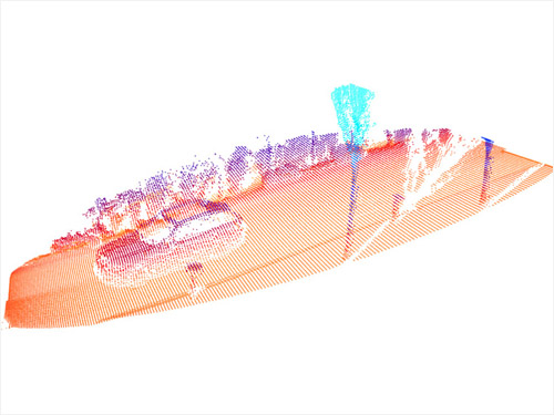
  • 3D Lidar point cloud processing (aerial and mobile) operations viz. data calibration, control correction, advanced classification/filtering, building modeling, terrain/DTM modeling, corridor mapping, tower/pole modeling etc.
  • Utility data modeling for electric/telecom/fiber (FTTH) networks and planimetric extraction of roadway assets and traffic signage from Lidar point clouds

Lidar Services

Large pool of professionals and analysts with expertise in 3D & Lidar data processing (static/ mobile/ aerial) with focus in areas of Terrain Modeling, Flood Mapping, 3D City Modeling, Airport Obstruction Surveys, Corridor & Right of Way Mapping, Utility Network Design/MRE, Transportation Clearance Analysis, Asset Inventory & Signage, Forest Mapping etc. Service include :

  • High fidelity classification of mobile and aerial Lidar by developing advanced filtering algorithms/macros
  • Lidar data calibration and control correction workflows
  • Accuracy assessment and reporting of Lidar data (FVA, CVA, SVA) using ASPRS standards
  • Terrain modeling, breakline creation and hydro-flattening workflows
  • Satellite image orthorectification workflows using Lidar derived DTMs through sensor model + RPC based geometric correction.
  • 2D & 3D Planimetric feature extraction
  • 3D building models/ BIM modeling
  • Asset Inventory/ Signage/ Finished Floor elevations (FFE)
  • 3D Utility pole network modeling for MRE design and FTTH network planning, etc.

GIS Consultancy

NeST’s team of Domain and Functional Consultants has expertise in conceptualizing and architecting GIS solutions to meet and exceed our customer requirements. Our consultancy services include:

  • Business process modeling and reengineering
  • Bid support & technical documentation services
  • System architecture & application design support
  • Data modeling and schema design
  • Process modeling using BPMN/ ITIL/ TOGAF frameworks
  • SME & GIS Cloud Implementation Support

Resource Augmentation

Nest GIS provides resource augmentation services by providing skilled technical resources for your in-house spatial projects. We can allocate dedicated GIS specialists, developers, architects usually offshore for the overseas development extensions of in-house application development / project teams on fixed or flexible pricing models.

  • Setup offshore development center (ODC) & services
  • Provide services of GIS specialists with expertise in business & GeoAnalytics
  • Provide expert developers in ArcGIS Enterprise, Portal, Dashboard, Insights, GeoAnalytics & GeoEvent Server
  • Provide developers with expertise in Machine Learning, Python, Big Data Analytics, 3D Modelling, Cloud GIS
  • Provide GIS data development experts and analysts for mapping services, 3D modelling, BIM, Lidar point cloud processing and visualization
  • Consultancy & partnership support for GIS and IT requirements.

Solutions

We have expertise in providing end-to-end quality spatial solutions for our clients from core domains like Utilities (Electric, Water, Telecom), Aviation, Local government and Facilities Management.

1Utility GIS
  • Success stories in streamlining various aspects of utility operations viz. Planning, Production, Distribution, Operations, Maintenance, Field Services etc.
  • GIS Integration experience
    • ERP and Asset Management software like JD Edwards
    • Operational Technologies like SCADA, DMS etc.
  • Development of Computerized Maintenance Management Systems (CMMS)
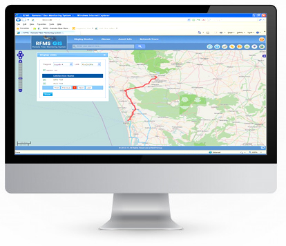
  • RFMS – GIS based Remote Fiber Management System for identification and mitigation of fiber network events/faults
  • Application Development capabilities in ArcFM and Facility Management solutions from IBM
  • Utility Pole Modeling and Clearance Analysis for FTTH rollout and planning operations
  • Consultancy & Application Development experience for County/City Administrations, Urban Planning bodies, Survey Departments etc.
  • Data Migration and application development services on Local Government Information Model, Survey Analyst etc.
  • Data Development and Survey Back Office Processing services related to landbase administration and maintenance
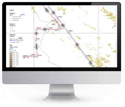
  • Complete automation of Flight Path Generation practice, utilized by multiple flight operators across the world
  • Experience in Esri and other navigation mapping technologies for creating maritime and aeronautical charts
  • Expertise in configuring Facilities Management applications from IBM
  • Integration of Asset Management applications with GIS
  • BIM / Revit Modeling
  • Floodplain Mapping applications
  • Finished Floor Elevation (FFE) Survey tools
  • Esri based editing & plotting applications for the creation of flood insurance rate maps
  • • Application and data development experience in multiple DoTs for ROW mapping, asset inventory, traffic signage etc.
  • Application development of Roadway Geometry calculation tools for Department of Transportation
  • Multimodal transit network modeling for metropolitan agency
  • Consultancy & Application development of logistics for ports, oil rigs and docks
  • ArcGIS Server and Location Analyst based applications for risk management and underwriting policy formulation
  • Insurance planning based on natural hazard zonation mapping

Products

We provide unique out-of-the-box products for clients from Aviation, Utility Industry etc. that is designed to meet their specific spatial needs..

alternative

FlIGIS

FliGIS is an aviation solution for analyzing and extracting the flight enroute parameters like maximum terrain height between way points, oxygen level profiles at a particular terrain heights etc., which in turn facilitates the complete automation of flight path generation for airliners. This product is highly popular among multiple airliners operating in India and Middle East. The product had also secured an award in the ESRI India user conference a few years ago.


alternative

OFC Network Inventory

Web GIS application for remote fiber monitoring and tracking of exact physical locations of various fiber events in a network. Built using industry standard geo-spatial data models and telecom network protocols, it also provides tools for finding best/alternate routes, tracing OTDR, dynamic display of network assets among others.


alternative

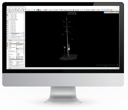
NCloud

NCloud is a customized Make-Ready Engineering (MRE) design solution for 3D modeling of utility pole networks for FTTH rollout operations. The solution provides high performance 3D point cloud visualization of Lidar data and multi-user editing capabilities for feature extraction and pole modeling based on each project specific schema. The scalable design architecture based on custom schema, rigorous mathematical algorithms for 3D modeling & validation, centralized database architecture, integration with industry leading pole loading/analysis softwares etc. make the product ideal for fiber network planning, clearance analysis, asset inventory, signage and many other utility surveys.

NeST GIS Case Studies

We work closely with our clients to provide complete solutions for their spatial and technical needs. By working closely and with integrity, we deliver seamless and integrated solutions to them.

alternative

TECHNICAL DRAWING MANAGEMENT SOLUTION

The objective of the project was to develop a solution encompassing an engine that allows GIS users to select drawings, catalogue, attribute, and store it in the GIS enterprise repository. It enables the user to modify or delete a drawing stored in the system based on the user privileges set in the application.
alternative

UTILITY POLE DATA EXTRACTION

The project objective was to update the database of utility poles by capturing data from the point cloud data using MicroStation tools and update attributes in MicroStation. The minimum features to be updated include poles and relevant attachments like wires, anchors, guys, transformers, street lights, etc. This data is used for pole loading analysis operations.
alternative

MOBILE GIS INFORMATION CAPTURE TOOL

M-ICAP tool (Mobile Information Capture) is an OGC compliant web-based mobile GIS application that can be deployed in mobile devices like UPDs, iPads, android phones, tablets etc. for efficient field data collection. The data capture mechanism is available in both online and offline mode. For devices, the pre-installed application plug-ins for GPS and camera prove vital for locating, route-tracking and image capture operations.
alternative

INTEGRATION WITH INTELLIGENT TRANSPORT

NeST developed a solution for integrating the traffic data information from WIM (Weigh in Motion) sensors installed on highways of a State in Unites States.

Contact Us

INDIA

  • NeST Towers, University junction, Kalamassery, Kochi, Kerala, India – 682 033
  • +91-484-6701000

  • NeST Tech Park, NeST Valley, Near Infopark, Infopark P.O, Kakkanad, Kochi, Kerala, India – 682042
  • +91484-4203333

  • No.70/4, Eliem building, 2nd cross, C.S.I compound, Mission road, Bangalore, Karnataka, India – 560 027

USA

  • 44901 Falcon Place, Suite 116, Sterling, VA 20166
  • 703-653-1100

Australia

  • Level 32, 101 Miller Street, North Sydney, NSW 2060, Australia
  • +61449925190, +61289122105

UAE

  • #203, 2nd Floor, Al Moosa Tower II, Sheikh Zayed Road, P O Box 83189, Dubai, UAE
  • +971 43252100, +971 565745642

JAPAN

  • Daiichi Meiji Building 2F, 3-3-11 Irifune Chuo-ku, Tokyo 104-0042 , JAPAN
  • 0081-3-6262-8989